Brookline’s Hidden Flood Risks: What New Maps Reveal and What They Miss
Brookline’s flood risk has long been a topic of curiosity for homeowners, investors, and local professionals. But this year, the release of FEMA’s updated flood maps sparked an important conversation: Is Brookline’s flood risk far higher than what the new maps show?
In June, FEMA introduced updated maps for Norfolk County. Brookline’s new map identifies 97 high‑risk parcels—properties with a 1% or greater annual flood chance requiring flood insurance. These parcels sit mostly around Leverett Pond and the Muddy River. Helpful as these tools are, local experts say they don’t tell the whole story.
Source: Brookline News — “Brookline’s flood risk may be higher than FEMA’s new map shows”
Read the original report
“There is a false sense of safety that many people assume if their property is not officially designated in a FEMA floodplain,” said Maria Rose, Brookline’s environmental engineer and floodplain administrator. “Flooding can happen anywhere.”
The Muddy River: Designed for Protection, Tested by Nature
Much of Brookline’s flood resilience traces back to Frederick Law Olmsted’s Emerald Necklace design—parklands surrounding waterways to buffer homes from flooding. Landscape historian Arleyn Levee emphasized that these green spaces weren’t just aesthetic; they were strategic environmental mitigation.
The town saw this system tested in the 1990s. In the floods of October 1996, more than 12 inches of rainfall overwhelmed the Muddy River system. Sediment, neglect, and obstructed waterways worsened the problem. Roads, stations, and buildings experienced significant damage.
In response, the Muddy River Restoration Project began—ultimately becoming a $92 million, decades-long effort completed largely by 2023. The improvements included dredging, invasive species removal, and daylighting buried river segments—restoring both ecological function and flood capacity.
Flooding Beyond the Riverbanks
While riverine flooding is the basis for FEMA’s models, it’s only part of the problem. Brookline experiences frequent pluvial flooding—flooding caused when stormwater overwhelms soil absorption and drainage systems.
Transportation corridors, MBTA stations, and roads bordering floodplains are vulnerable during significant rain events. Residents voiced major concerns about access, travel disruption, and emergency response times during Brookline’s Climate Action and Resiliency Plan (CARP) development.
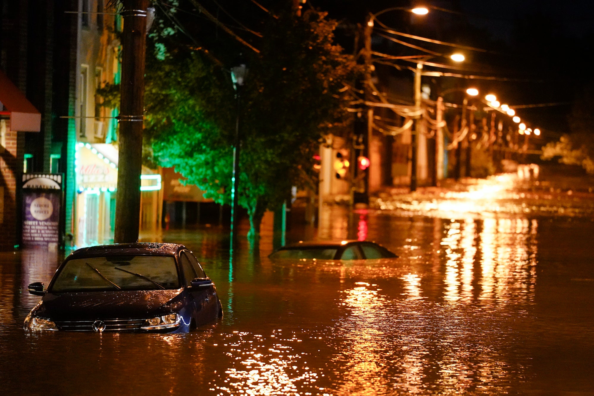
Beacon Street: The Flooding That FEMA Doesn’t Capture
Beacon Street is one of Brookline’s most flood‑prone corridors, yet FEMA’s map labels the area low‑risk. Another model reveals a different truth.
Explore the Interactive Map: First Street Flood Factor offers a richer look at flood risks, including rainfall, tides, surges, and climate‑driven changes.
When First Street’s factors are considered, the number of Brookline properties at risk over the next 30 years jumps to over 1,300—nearly a quarter of the town.
Flood modeler Daniel Rees notes that flood maps are only “one view” of a broad, uncertain future. Being “just inside” or “just outside” a FEMA zone can mean drastically different risk levels.
Other tools, such as the USGS Coastal Change Hazards Portal, Massachusetts CZM Hurricane Surge map, and NOAA’s Sea Level Rise Viewer, provide additional lenses for evaluating risk.
Climate Change and Urbanization: A Growing Threat
Brookline officials warn that changing climate patterns are intensifying storms and reshaping flood risk. More frequent downpours combined with hard urban surfaces reduce natural water absorption, amplifying flooding potential.
“The amount of water that is now coming down in a storm is unbelievable,” Levee said, expressing doubt about whether traditional flood control designs can handle modern extremes.
Rees raised concerns familiar to many real estate and insurance professionals: Could areas like Brookline see future impacts on property values—or even insurability?
How Soon Until Brookline’s Next Big Flood?
While storms causing nuisance flooding are expected, flash floods—like those in 1996—pose serious risk even in places labeled “low‑risk.” Nationwide, over 40% of flood insurance claims come from properties outside FEMA high‑risk zones.
This reality puts communities like Brookline on alert. Climate‑fueled storms have caused catastrophic flooding in cities across the U.S. in recent years. Local officials worry that a similarly intense event could overwhelm culverts, road systems, and restored waterways.
For now, flood control measures stand ready—but their true test may be closer than residents expect.
Professionals Take Note:
Flood literacy is becoming essential for real estate agents, adjusters, insurers, and urban planners. At Cameron Academy, we train professionals nationwide to recognize environmental factors that influence property value, insurance needs, and long‑term risk.
Getting licensed or staying ahead in your career can be a journey—but it doesn’t have to be overwhelming. Grab your favorite coffee or tea, take a moment to relax, and browse through our articles. Whether you’re just starting out or renewing your expertise, we’ve got tips, insights, and advice to keep you moving forward. Here’s to your success—one sip and one step at a time!
Seattle now holds the second‑highest office vacancy rate in the nation at 26.6%, with some downtown areas soaring past 35% and Pioneer Square reaching 50%. Mayor‑elect Katie Wilson steps into office with bold proposals—including a vacancy tax and office‑to‑housing conversions—amid tech pullbacks, shifting work habits, and investor uncertainty. Despite alarming numbers, signs of resilience remain, offering opportunities for savvy real estate professionals watching this market transform in real time.
Florida lawmakers are once again targeting the fast‑growing litigation‑financing industry with House Bill 1157, a proposal that would restrict how outside investors participate in lawsuits. The bill would limit funder influence, cap their share of settlements, and require new disclosures—especially for foreign‑backed financing. As similar measures emerge nationwide, the outcome could significantly impact professionals across law, insurance, finance, and real estate who depend on predictable risk and regulatory environments.
Starting April 1, Philadelphia homeowners and renters with federal flood insurance will see a 15% reduction in their premiums thanks to the city joining FEMA’s Community Rating System. The discount reflects Philadelphia’s growing investment in flood‑risk mitigation and is expected to save residents and businesses more than $424,000 annually. Beyond easing household expenses, the change also reshapes how real estate and insurance professionals evaluate flood‑zone properties, opening the door to improved affordability and stronger buyer confidence.
Newrez is doubling down on artificial intelligence with a strategic investment in Homevision, an advanced AI underwriting platform designed to automate collateral, income, assets, credit, and full loan decisioning. After seeing Homevision’s MIRA system boost collateral underwriting efficiency, Newrez plans to expand the technology in 2026—signaling a breakthrough year for real-time automated underwriting across the mortgage industry.
A new United Van Lines migration report reveals that Americans are trading big-city ambition for affordability, shorter commutes, and better quality of life—reshaping where and how commercial real estate will grow. Southern and smaller markets continue to attract new residents, but pandemic‑era assumptions of endless demand are fading as rent growth cools and new inventory floods the market. For investors and real estate professionals, the opportunity now lies in affordable housing, modest office parks, value‑focused retail, and support‑industrial spaces like self‑storage.
The 2026 housing market is finally shifting into balance, with economists forecasting rising home sales, improved affordability, and a more diverse buyer pool. Inventory is up, mortgage rates are easing, and demographic changes—from returning first-time buyers to dominant baby boomers—are reshaping demand. New construction is stabilizing, price growth is moderating, and millions of buyers could re-enter the market as rates fall toward 6 percent. For real estate professionals, this rebalanced environment offers fresh opportunities for growth, strategy, and education.


