Brookline’s Hidden Flood Risks: What New Maps Reveal and What They Miss
Brookline’s flood risk has long been a topic of curiosity for homeowners, investors, and local professionals. But this year, the release of FEMA’s updated flood maps sparked an important conversation: Is Brookline’s flood risk far higher than what the new maps show?
In June, FEMA introduced updated maps for Norfolk County. Brookline’s new map identifies 97 high‑risk parcels—properties with a 1% or greater annual flood chance requiring flood insurance. These parcels sit mostly around Leverett Pond and the Muddy River. Helpful as these tools are, local experts say they don’t tell the whole story.
Source: Brookline News — “Brookline’s flood risk may be higher than FEMA’s new map shows”
Read the original report
“There is a false sense of safety that many people assume if their property is not officially designated in a FEMA floodplain,” said Maria Rose, Brookline’s environmental engineer and floodplain administrator. “Flooding can happen anywhere.”
The Muddy River: Designed for Protection, Tested by Nature
Much of Brookline’s flood resilience traces back to Frederick Law Olmsted’s Emerald Necklace design—parklands surrounding waterways to buffer homes from flooding. Landscape historian Arleyn Levee emphasized that these green spaces weren’t just aesthetic; they were strategic environmental mitigation.
The town saw this system tested in the 1990s. In the floods of October 1996, more than 12 inches of rainfall overwhelmed the Muddy River system. Sediment, neglect, and obstructed waterways worsened the problem. Roads, stations, and buildings experienced significant damage.
In response, the Muddy River Restoration Project began—ultimately becoming a $92 million, decades-long effort completed largely by 2023. The improvements included dredging, invasive species removal, and daylighting buried river segments—restoring both ecological function and flood capacity.
Flooding Beyond the Riverbanks
While riverine flooding is the basis for FEMA’s models, it’s only part of the problem. Brookline experiences frequent pluvial flooding—flooding caused when stormwater overwhelms soil absorption and drainage systems.
Transportation corridors, MBTA stations, and roads bordering floodplains are vulnerable during significant rain events. Residents voiced major concerns about access, travel disruption, and emergency response times during Brookline’s Climate Action and Resiliency Plan (CARP) development.
Beacon Street: The Flooding That FEMA Doesn’t Capture
Beacon Street is one of Brookline’s most flood‑prone corridors, yet FEMA’s map labels the area low‑risk. Another model reveals a different truth.
Explore the Interactive Map: First Street Flood Factor offers a richer look at flood risks, including rainfall, tides, surges, and climate‑driven changes.
When First Street’s factors are considered, the number of Brookline properties at risk over the next 30 years jumps to over 1,300—nearly a quarter of the town.
Flood modeler Daniel Rees notes that flood maps are only “one view” of a broad, uncertain future. Being “just inside” or “just outside” a FEMA zone can mean drastically different risk levels.
Other tools, such as the USGS Coastal Change Hazards Portal, Massachusetts CZM Hurricane Surge map, and NOAA’s Sea Level Rise Viewer, provide additional lenses for evaluating risk.
Climate Change and Urbanization: A Growing Threat
Brookline officials warn that changing climate patterns are intensifying storms and reshaping flood risk. More frequent downpours combined with hard urban surfaces reduce natural water absorption, amplifying flooding potential.
“The amount of water that is now coming down in a storm is unbelievable,” Levee said, expressing doubt about whether traditional flood control designs can handle modern extremes.
Rees raised concerns familiar to many real estate and insurance professionals: Could areas like Brookline see future impacts on property values—or even insurability?
How Soon Until Brookline’s Next Big Flood?
While storms causing nuisance flooding are expected, flash floods—like those in 1996—pose serious risk even in places labeled “low‑risk.” Nationwide, over 40% of flood insurance claims come from properties outside FEMA high‑risk zones.
This reality puts communities like Brookline on alert. Climate‑fueled storms have caused catastrophic flooding in cities across the U.S. in recent years. Local officials worry that a similarly intense event could overwhelm culverts, road systems, and restored waterways.
For now, flood control measures stand ready—but their true test may be closer than residents expect.
Professionals Take Note:
Flood literacy is becoming essential for real estate agents, adjusters, insurers, and urban planners. At Cameron Academy, we train professionals nationwide to recognize environmental factors that influence property value, insurance needs, and long‑term risk.
Getting licensed or staying ahead in your career can be a journey—but it doesn’t have to be overwhelming. Grab your favorite coffee or tea, take a moment to relax, and browse through our articles. Whether you’re just starting out or renewing your expertise, we’ve got tips, insights, and advice to keep you moving forward. Here’s to your success—one sip and one step at a time!
Florida families are feeling the squeeze as everyday costs, insurance premiums, and homeownership barriers continue to climb. House District 102 candidate Jayden D’Onofrio is calling for a broader, more unified affordability strategy—one that tackles the state’s insurance crisis, supports first‑time homebuyers, and restores real competition in the market. His message centers on transparency, practical solutions, and keeping Florida livable for the professionals, workers, and families who power its economy.
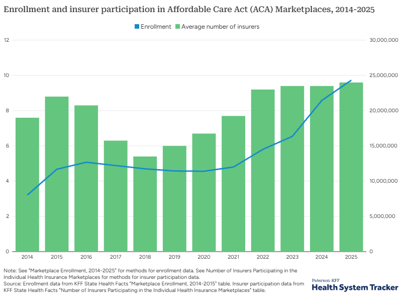
A decade of dramatic change is reshaping America’s health insurance markets. Employer group plans are becoming increasingly dominated by a few powerful insurers, while the ACA individual marketplace is experiencing record‑breaking competition and enrollment. Self‑funded plans are surging, small‑group premiums are driving employers to new coverage models, and major policy shifts in 2025 could redefine affordability for millions. This data‑driven Peterson‑KFF analysis breaks down the trends every insurance, finance, and business professional needs to understand as the industry enters a transformative new era.
Sarasota County is inching closer to approving Winchester Ranch, a massive 8,999‑home community planned for more than 3,100 acres in North Port. With a 7‑1 vote from the Planning Commission and a final decision expected in early 2026, the project could become one of Southwest Florida’s largest developments in decades—bringing new housing, commercial space, and industry while raising fresh questions about growth, the environment, and the region’s rapidly evolving real estate market.
Lument Finance Trust has closed a major $663.8 million commercial real estate CLO, marking one of the standout CRE finance deals of 2025. The transaction, LMNT 2025-FL3, features a strong reinvestment period, non‑recourse and non‑mark‑to‑market financing, and a diversified pool of 32 loans tied to 49 properties nationwide. With J.P. Morgan leading the structuring and more than $585 million placed in investment‑grade securities, the deal highlights renewed stability in transitional CRE debt—making it a development real estate and finance professionals will want to watch closely.
Walmart has partnered with Alquist 3D to roll out the nation’s first large‑scale wave of 3D‑printed commercial buildings, signaling a major shift in how future retail and industrial spaces will be constructed. After completing an 8,000‑square‑foot 3D‑printed expansion in Tennessee—the largest of its kind—the company is moving forward with over a dozen new projects nationwide, accelerating a tech‑driven transformation in commercial real estate.
Citizens Property Insurance Corp. is recommending statewide rate reductions for 2026—the first proposed decrease in more than a decade. Most Citizens policyholders could see an average 11.5% drop, reflecting recent insurance‑market reforms that have stabilized Florida’s turbulent property sector. With hundreds of thousands of policies moving back to private insurers and state‑backed Citizens shrinking to record‑low enrollment, real estate and insurance professionals should prepare for how lower premiums may influence affordability, buyer confidence, and market activity heading into 2026.


