Brookline’s Hidden Flood Risks: What New Maps Reveal and What They Miss
Brookline’s flood risk has long been a topic of curiosity for homeowners, investors, and local professionals. But this year, the release of FEMA’s updated flood maps sparked an important conversation: Is Brookline’s flood risk far higher than what the new maps show?
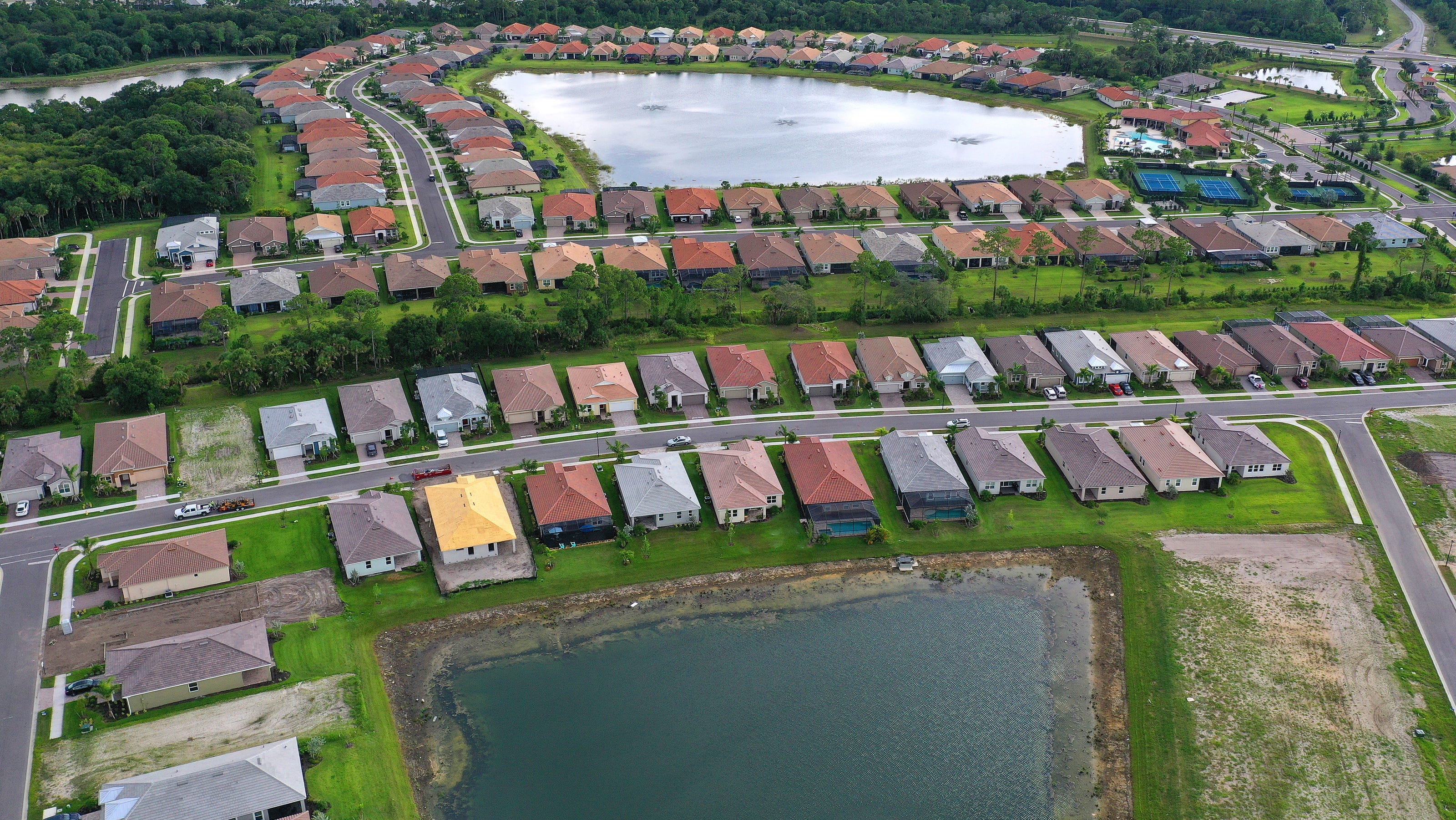
In June, FEMA introduced updated maps for Norfolk County. Brookline’s new map identifies 97 high‑risk parcels—properties with a 1% or greater annual flood chance requiring flood insurance. These parcels sit mostly around Leverett Pond and the Muddy River. Helpful as these tools are, local experts say they don’t tell the whole story.
Source: Brookline News — “Brookline’s flood risk may be higher than FEMA’s new map shows”
Read the original report
“There is a false sense of safety that many people assume if their property is not officially designated in a FEMA floodplain,” said Maria Rose, Brookline’s environmental engineer and floodplain administrator. “Flooding can happen anywhere.”
The Muddy River: Designed for Protection, Tested by Nature
Much of Brookline’s flood resilience traces back to Frederick Law Olmsted’s Emerald Necklace design—parklands surrounding waterways to buffer homes from flooding. Landscape historian Arleyn Levee emphasized that these green spaces weren’t just aesthetic; they were strategic environmental mitigation.
The town saw this system tested in the 1990s. In the floods of October 1996, more than 12 inches of rainfall overwhelmed the Muddy River system. Sediment, neglect, and obstructed waterways worsened the problem. Roads, stations, and buildings experienced significant damage.
In response, the Muddy River Restoration Project began—ultimately becoming a $92 million, decades-long effort completed largely by 2023. The improvements included dredging, invasive species removal, and daylighting buried river segments—restoring both ecological function and flood capacity.
Flooding Beyond the Riverbanks
While riverine flooding is the basis for FEMA’s models, it’s only part of the problem. Brookline experiences frequent pluvial flooding—flooding caused when stormwater overwhelms soil absorption and drainage systems.
Transportation corridors, MBTA stations, and roads bordering floodplains are vulnerable during significant rain events. Residents voiced major concerns about access, travel disruption, and emergency response times during Brookline’s Climate Action and Resiliency Plan (CARP) development.
Beacon Street: The Flooding That FEMA Doesn’t Capture
Beacon Street is one of Brookline’s most flood‑prone corridors, yet FEMA’s map labels the area low‑risk. Another model reveals a different truth.
Explore the Interactive Map: First Street Flood Factor offers a richer look at flood risks, including rainfall, tides, surges, and climate‑driven changes.
When First Street’s factors are considered, the number of Brookline properties at risk over the next 30 years jumps to over 1,300—nearly a quarter of the town.
Flood modeler Daniel Rees notes that flood maps are only “one view” of a broad, uncertain future. Being “just inside” or “just outside” a FEMA zone can mean drastically different risk levels.
Other tools, such as the USGS Coastal Change Hazards Portal, Massachusetts CZM Hurricane Surge map, and NOAA’s Sea Level Rise Viewer, provide additional lenses for evaluating risk.
Climate Change and Urbanization: A Growing Threat
Brookline officials warn that changing climate patterns are intensifying storms and reshaping flood risk. More frequent downpours combined with hard urban surfaces reduce natural water absorption, amplifying flooding potential.
“The amount of water that is now coming down in a storm is unbelievable,” Levee said, expressing doubt about whether traditional flood control designs can handle modern extremes.
Rees raised concerns familiar to many real estate and insurance professionals: Could areas like Brookline see future impacts on property values—or even insurability?
How Soon Until Brookline’s Next Big Flood?
While storms causing nuisance flooding are expected, flash floods—like those in 1996—pose serious risk even in places labeled “low‑risk.” Nationwide, over 40% of flood insurance claims come from properties outside FEMA high‑risk zones.
This reality puts communities like Brookline on alert. Climate‑fueled storms have caused catastrophic flooding in cities across the U.S. in recent years. Local officials worry that a similarly intense event could overwhelm culverts, road systems, and restored waterways.
For now, flood control measures stand ready—but their true test may be closer than residents expect.
Professionals Take Note:
Flood literacy is becoming essential for real estate agents, adjusters, insurers, and urban planners. At Cameron Academy, we train professionals nationwide to recognize environmental factors that influence property value, insurance needs, and long‑term risk.
Getting licensed or staying ahead in your career can be a journey—but it doesn’t have to be overwhelming. Grab your favorite coffee or tea, take a moment to relax, and browse through our articles. Whether you’re just starting out or renewing your expertise, we’ve got tips, insights, and advice to keep you moving forward. Here’s to your success—one sip and one step at a time!
Fintech has evolved from simple digital banking tools into a global force transforming how we pay, borrow, invest, and manage financial data. With AI, blockchain, and open banking leading the way, fintech is opening new opportunities for consumers, businesses, and professionals across real estate, mortgage, insurance, and finance.
After months of hesitation, the commercial real estate market showed a major resurgence in Q3 2025. Large single‑asset transactions over $10 million jumped to $76 billion — the strongest level since 2022 — signaling renewed liquidity and growing confidence among institutional buyers. While overall volumes remain below peak highs, rising deal counts, stabilizing prices, and increased activity across industrial, multifamily, office, and retail sectors point toward a market steadily moving back toward normalization.
California’s property insurance market didn’t collapse overnight—it unraveled over years of political delays, soaring wildfire losses, and mounting pressure on insurers and reinsurers. As major carriers pulled out and rate approvals stalled, millions of homeowners were left scrambling for coverage under an overwhelmed FAIR Plan. At the center of the controversy stands Insurance Commissioner Ricardo Lara, whose decisions, industry ties, and behind‑the‑scenes negotiations have drawn sharp criticism. The result is a destabilized market affecting homeowners, real estate professionals, lenders, and entire communities—and the question of whether current reforms can truly fix what’s broken.
After a slow start to the year, commercial real estate showed a major resurgence in Q3 2025 as large single‑asset deals over $10 million surged past $76 billion in volume. With 1,826 major trades and the strongest growth rate in more than a decade, investor confidence appears to be returning across U.S. markets. While overall volumes still trail the record highs of 2021–2022, the renewed momentum in big‑ticket transactions points to improving liquidity, clearer pricing, and a potentially pivotal turning point for brokers, investors, and industry professionals.
California’s property insurance market has unraveled into one of the most expensive and consequential crises in U.S. history. Major carriers pulled back, wildfire risks soared, regulators stalled, and the state’s FAIR Plan exploded in size — leaving hundreds of thousands of homeowners without affordable coverage. Now, with victims underinsured, premiums surging, and a billion‑dollar bailout looming, the fallout is spilling beyond California. For real estate, mortgage, finance, and insurance professionals across the country, this is a warning of what happens when rising climate risks collide with outdated regulatory systems.
Sarasota County is on the brink of one of its largest modern expansions as the Winchester Ranch project moves closer to approval. Spanning more than 3,100 acres near North Port, the planned mega-development could bring up to 8,999 homes plus major commercial and industrial space. With construction projected to begin in 2027–2028, the community has sparked both excitement over new housing opportunities and concerns about environmental impact, placing it at the center of Florida’s ongoing growth debate.


