Brookline’s Hidden Flood Risks: What New Maps Reveal and What They Miss
Brookline’s flood risk has long been a topic of curiosity for homeowners, investors, and local professionals. But this year, the release of FEMA’s updated flood maps sparked an important conversation: Is Brookline’s flood risk far higher than what the new maps show?
In June, FEMA introduced updated maps for Norfolk County. Brookline’s new map identifies 97 high‑risk parcels—properties with a 1% or greater annual flood chance requiring flood insurance. These parcels sit mostly around Leverett Pond and the Muddy River. Helpful as these tools are, local experts say they don’t tell the whole story.
Source: Brookline News — “Brookline’s flood risk may be higher than FEMA’s new map shows”
Read the original report
“There is a false sense of safety that many people assume if their property is not officially designated in a FEMA floodplain,” said Maria Rose, Brookline’s environmental engineer and floodplain administrator. “Flooding can happen anywhere.”
The Muddy River: Designed for Protection, Tested by Nature
Much of Brookline’s flood resilience traces back to Frederick Law Olmsted’s Emerald Necklace design—parklands surrounding waterways to buffer homes from flooding. Landscape historian Arleyn Levee emphasized that these green spaces weren’t just aesthetic; they were strategic environmental mitigation.
The town saw this system tested in the 1990s. In the floods of October 1996, more than 12 inches of rainfall overwhelmed the Muddy River system. Sediment, neglect, and obstructed waterways worsened the problem. Roads, stations, and buildings experienced significant damage.
In response, the Muddy River Restoration Project began—ultimately becoming a $92 million, decades-long effort completed largely by 2023. The improvements included dredging, invasive species removal, and daylighting buried river segments—restoring both ecological function and flood capacity.
Flooding Beyond the Riverbanks
While riverine flooding is the basis for FEMA’s models, it’s only part of the problem. Brookline experiences frequent pluvial flooding—flooding caused when stormwater overwhelms soil absorption and drainage systems.
Transportation corridors, MBTA stations, and roads bordering floodplains are vulnerable during significant rain events. Residents voiced major concerns about access, travel disruption, and emergency response times during Brookline’s Climate Action and Resiliency Plan (CARP) development.
Beacon Street: The Flooding That FEMA Doesn’t Capture
Beacon Street is one of Brookline’s most flood‑prone corridors, yet FEMA’s map labels the area low‑risk. Another model reveals a different truth.
Explore the Interactive Map: First Street Flood Factor offers a richer look at flood risks, including rainfall, tides, surges, and climate‑driven changes.
When First Street’s factors are considered, the number of Brookline properties at risk over the next 30 years jumps to over 1,300—nearly a quarter of the town.
Flood modeler Daniel Rees notes that flood maps are only “one view” of a broad, uncertain future. Being “just inside” or “just outside” a FEMA zone can mean drastically different risk levels.
Other tools, such as the USGS Coastal Change Hazards Portal, Massachusetts CZM Hurricane Surge map, and NOAA’s Sea Level Rise Viewer, provide additional lenses for evaluating risk.
Climate Change and Urbanization: A Growing Threat
Brookline officials warn that changing climate patterns are intensifying storms and reshaping flood risk. More frequent downpours combined with hard urban surfaces reduce natural water absorption, amplifying flooding potential.
“The amount of water that is now coming down in a storm is unbelievable,” Levee said, expressing doubt about whether traditional flood control designs can handle modern extremes.
Rees raised concerns familiar to many real estate and insurance professionals: Could areas like Brookline see future impacts on property values—or even insurability?
How Soon Until Brookline’s Next Big Flood?
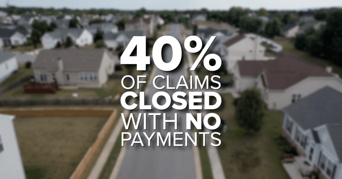
While storms causing nuisance flooding are expected, flash floods—like those in 1996—pose serious risk even in places labeled “low‑risk.” Nationwide, over 40% of flood insurance claims come from properties outside FEMA high‑risk zones.
This reality puts communities like Brookline on alert. Climate‑fueled storms have caused catastrophic flooding in cities across the U.S. in recent years. Local officials worry that a similarly intense event could overwhelm culverts, road systems, and restored waterways.
For now, flood control measures stand ready—but their true test may be closer than residents expect.
Professionals Take Note:
Flood literacy is becoming essential for real estate agents, adjusters, insurers, and urban planners. At Cameron Academy, we train professionals nationwide to recognize environmental factors that influence property value, insurance needs, and long‑term risk.
Getting licensed or staying ahead in your career can be a journey—but it doesn’t have to be overwhelming. Grab your favorite coffee or tea, take a moment to relax, and browse through our articles. Whether you’re just starting out or renewing your expertise, we’ve got tips, insights, and advice to keep you moving forward. Here’s to your success—one sip and one step at a time!
Just 48 hours after NAR unveiled major revisions to its MLS policies, plaintiffs in the Michigan-based Hardy lawsuit moved to use those changes as evidence, arguing they prove NAR’s prior rules were anticompetitive. NAR denies any wrongdoing, but the case is quickly becoming a key test for whether MLS access should require Realtor membership — a question now echoing across multiple states and potentially reshaping how real estate professionals nationwide access the industry’s most essential tool.
Florida homeowners are now paying some of the highest insurance premiums in the country, with average costs topping $5,800 per year—nearly double the national average. Residents report skyrocketing rates, denied claims, and tough choices between costly coverage and financial risk. As frustration grows, lawmakers and consumer advocates are pushing new reforms aimed at increasing transparency, capping rate hikes, and protecting policyholders in one of the nation’s most volatile insurance markets.
Economic uncertainty, rapid AI adoption, tighter capital flows, and rising portfolio risk are reshaping the 2026 commercial real estate landscape. From shifting workforce patterns to a national housing attainability crisis, the industry is entering a data‑driven, fundamentals‑focused era—making adaptability, education, and tech literacy essential for real estate professionals.
Mortgage rates have climbed to 6.23 percent as investors grow doubtful that the Federal Reserve will deliver a rate cut in December. A soft but unclear jobs report and persistent inflation have pushed borrowing costs higher, reversing October’s brief relief in the housing market. Real estate and mortgage professionals should prepare clients for continued volatility as the Fed’s December meeting approaches.
After years of tight inventory, high mortgage rates, and sluggish sales, economists say 2026 is shaping up to be the turnaround real estate professionals have been waiting for. NAR projects a 14 percent jump in home sales, mortgage rates easing toward 6 percent, and buyer demand finally gaining momentum. While higher‑end homes are moving quickly, first‑time buyers continue to face affordability challenges, and price reductions are reappearing as sellers adjust to shifting conditions. For Florida agents, brokers, and newcomers, the stage is being set for a busy and opportunity‑rich year.
Florida’s average homeowner insurance premium has soared to $5,838 a year—almost $3,000 above the national average—pushing many residents to the financial brink. From tripled premiums to lowball claim payouts, homeowners are speaking out as frustration mounts. Some are even dropping coverage entirely. With more than 40% of claims closed without payment and policy cancellations at record levels, lawmakers are pushing for reforms, but political hurdles remain. The outcome could reshape Florida real estate, insurance, and mortgage markets for years to come.


