Brookline’s Hidden Flood Risks: What New Maps Reveal and What They Miss
Brookline’s flood risk has long been a topic of curiosity for homeowners, investors, and local professionals. But this year, the release of FEMA’s updated flood maps sparked an important conversation: Is Brookline’s flood risk far higher than what the new maps show?
In June, FEMA introduced updated maps for Norfolk County. Brookline’s new map identifies 97 high‑risk parcels—properties with a 1% or greater annual flood chance requiring flood insurance. These parcels sit mostly around Leverett Pond and the Muddy River. Helpful as these tools are, local experts say they don’t tell the whole story.
Source: Brookline News — “Brookline’s flood risk may be higher than FEMA’s new map shows”
Read the original report
“There is a false sense of safety that many people assume if their property is not officially designated in a FEMA floodplain,” said Maria Rose, Brookline’s environmental engineer and floodplain administrator. “Flooding can happen anywhere.”
The Muddy River: Designed for Protection, Tested by Nature
Much of Brookline’s flood resilience traces back to Frederick Law Olmsted’s Emerald Necklace design—parklands surrounding waterways to buffer homes from flooding. Landscape historian Arleyn Levee emphasized that these green spaces weren’t just aesthetic; they were strategic environmental mitigation.
The town saw this system tested in the 1990s. In the floods of October 1996, more than 12 inches of rainfall overwhelmed the Muddy River system. Sediment, neglect, and obstructed waterways worsened the problem. Roads, stations, and buildings experienced significant damage.
In response, the Muddy River Restoration Project began—ultimately becoming a $92 million, decades-long effort completed largely by 2023. The improvements included dredging, invasive species removal, and daylighting buried river segments—restoring both ecological function and flood capacity.
Flooding Beyond the Riverbanks
While riverine flooding is the basis for FEMA’s models, it’s only part of the problem. Brookline experiences frequent pluvial flooding—flooding caused when stormwater overwhelms soil absorption and drainage systems.
Transportation corridors, MBTA stations, and roads bordering floodplains are vulnerable during significant rain events. Residents voiced major concerns about access, travel disruption, and emergency response times during Brookline’s Climate Action and Resiliency Plan (CARP) development.
Beacon Street: The Flooding That FEMA Doesn’t Capture
Beacon Street is one of Brookline’s most flood‑prone corridors, yet FEMA’s map labels the area low‑risk. Another model reveals a different truth.
Explore the Interactive Map: First Street Flood Factor offers a richer look at flood risks, including rainfall, tides, surges, and climate‑driven changes.
When First Street’s factors are considered, the number of Brookline properties at risk over the next 30 years jumps to over 1,300—nearly a quarter of the town.
Flood modeler Daniel Rees notes that flood maps are only “one view” of a broad, uncertain future. Being “just inside” or “just outside” a FEMA zone can mean drastically different risk levels.
Other tools, such as the USGS Coastal Change Hazards Portal, Massachusetts CZM Hurricane Surge map, and NOAA’s Sea Level Rise Viewer, provide additional lenses for evaluating risk.
Climate Change and Urbanization: A Growing Threat
Brookline officials warn that changing climate patterns are intensifying storms and reshaping flood risk. More frequent downpours combined with hard urban surfaces reduce natural water absorption, amplifying flooding potential.
“The amount of water that is now coming down in a storm is unbelievable,” Levee said, expressing doubt about whether traditional flood control designs can handle modern extremes.
Rees raised concerns familiar to many real estate and insurance professionals: Could areas like Brookline see future impacts on property values—or even insurability?
How Soon Until Brookline’s Next Big Flood?
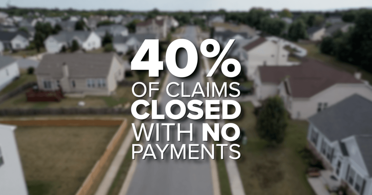
While storms causing nuisance flooding are expected, flash floods—like those in 1996—pose serious risk even in places labeled “low‑risk.” Nationwide, over 40% of flood insurance claims come from properties outside FEMA high‑risk zones.
This reality puts communities like Brookline on alert. Climate‑fueled storms have caused catastrophic flooding in cities across the U.S. in recent years. Local officials worry that a similarly intense event could overwhelm culverts, road systems, and restored waterways.
For now, flood control measures stand ready—but their true test may be closer than residents expect.
Professionals Take Note:
Flood literacy is becoming essential for real estate agents, adjusters, insurers, and urban planners. At Cameron Academy, we train professionals nationwide to recognize environmental factors that influence property value, insurance needs, and long‑term risk.
Getting licensed or staying ahead in your career can be a journey—but it doesn’t have to be overwhelming. Grab your favorite coffee or tea, take a moment to relax, and browse through our articles. Whether you’re just starting out or renewing your expertise, we’ve got tips, insights, and advice to keep you moving forward. Here’s to your success—one sip and one step at a time!
A surge in home insurance premiums is reshaping housing markets across the country, hitting disaster‑prone regions the hardest. From Louisiana to Colorado and California, deals are collapsing, buyers are backing out, and home values are dropping as insurance becomes a central affordability hurdle. New data shows climate‑driven risk repricing and soaring reinsurance costs are stripping tens of thousands of dollars from property values, forcing some homeowners to sell at a loss—or go uninsured altogether.
After years of sluggish activity, the National Association of REALTORS predicts 2026 could mark the long‑awaited rebound for the housing market. With a projected 14% jump in home sales, steadier rates near 6%, and rising buyer activity, NAR economists say momentum is already building. Early signs—like a 31% surge in mortgage applications, continued job growth, and stabilizing prices—suggest a stronger, more confident market ahead, creating fresh opportunities for both seasoned professionals and aspiring agents preparing to enter the field.
A surge of global capital is reshaping real estate heading into 2026, with investors shifting toward hands‑on strategies, cross‑border diversification, and high‑growth asset classes like data centers. Colliers’ 2026 Global Investor Outlook highlights rising confidence, improving liquidity, and a major pivot toward direct investing and value‑add opportunities. From office market rebounds to Asia Pacific’s rapid fundraising growth, the report outlines trends every real estate professional should understand as the industry enters a more dynamic, opportunity‑rich cycle.
Culver City just became the first place in California to legalize six‑story apartment buildings with only one staircase — a simple change that could reshape mid‑rise housing statewide. By freeing up as much as 7% more usable floor space, architects say single‑stair designs allow bigger units, more windows, and the kind of elegant layouts common in New York and Europe. If the city’s six‑year experiment succeeds, it may spark a broader rethinking of U.S. building codes and open the door to more flexible, affordable multifamily development across California.
Stratford homeowners are receiving their 2025 Notices of Assessment Change, marking the town’s first property revaluation since 2019. Officials emphasize that rising assessments do not equal higher tax bills, as a new mill rate won’t be set until spring 2026. Residents can challenge or review their updated valuations through informal hearings hosted by Vision Government Solutions, with appointments available for one week after receiving a notice.
New reporting reveals Florida homeowners now face an average insurance premium of $5,838 per year — nearly triple the national average. With skyrocketing rates, denied claims, and mounting non-renewals, residents are being pushed to tough financial decisions while lawmakers scramble to implement reforms. From retirees skipping coverage to families battling insurers for fair payouts, Florida’s insurance crisis is reshaping both the housing market and the daily lives of homeowners statewide.


